
Downloadable Route Summary & Instructions for Allendale Town to Ninebanks (St Mark’s Church)
Summary

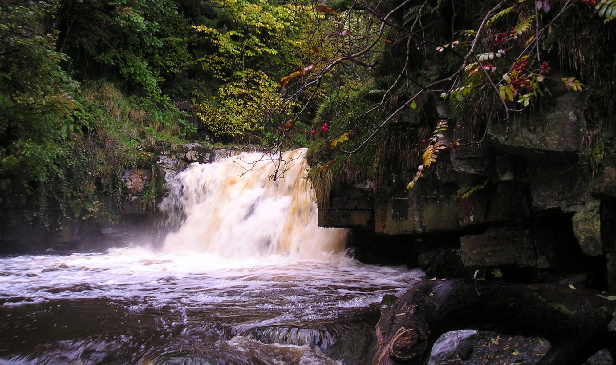
The trail begins in Allendale from Isaac’s Well and follows the River East Allen down the valley.
Initially the riverside path is in a corridor of woodland, then it opens out into hay meadows where sheep, cattle and horses graze. Behind such pastoral images is a fascinating industrial history when the valley led the world, albeit briefly, in mining technology.
By the mid 1800s it was the Silicon Valley of its day with revolutionary hydraulic engines from W.G. Armstong’s Elswick works in Newcastle installed in the shafts to drain the Blackett Level mines then under construction. So named after the landowners, the Blackett Beaumonts, it was an ambitious engineering project for an underground channel up from Allendale to Allenheads. It was also intended to discover new mineral veins. In the long run, the costly scheme was not a success. The surveying and engineering required may owe something to Allendale’s claim to be the Centre of Britain.
The trail then leaves the East Allen and climbs over to the West Allen Valley past Keenley Chapel. First visited by John Wesley in 1746 and is now the oldest chapel in continuous use in the world from 1750.
The trail continues into Monk Wood part of the Whitfield Estate. Eventually reaching the road at Leadgate Bank. From Dryburn the route then descends down into Ninebanks, where St Mark’s Church and the Hearse House can be found.
Both Isaac’s parents and his older brother Jonathan were buried at St. Mark’s Church, Ninebanks. You will not find their gravestones, they were too poor to afford the cost. A short distance up the road is the purpose-built hearse house now fully restored. This melancholy venture was his last with the funds raised before his own death in 1857. It was only the year before he presented the hearse on the grand occasion of the official opening of the schools at Ninebanks. Take the time to visit the hearse house and put your name in the visitors’ book.
Isaac was fortunate, for just when lead mining was at a low ebb in the 1830s, the market for tea was growing year on year. The success of the Holden enterprise probably owes more than a little to custom from the extended Holden family and friends in the neighbourhood. Neither should it be underestimated the insatiable demand for tea in this staunchly Methodist community. Around Ninebanks alone were six temperance oriented Methodist chapels keen to indulge in “the drink that cheers but does not inebriate”.
Accommodation and refreshments are available in Allendale
Distance: 12.8km, 7.9 miles. Allow 4 hours
Difficulty: Medium
Max height: 349m Min height: 176m Total Climb: 347m
Maps: Allendale Town – Ninebanks (St Mark’s Church) Map
Route Instructions
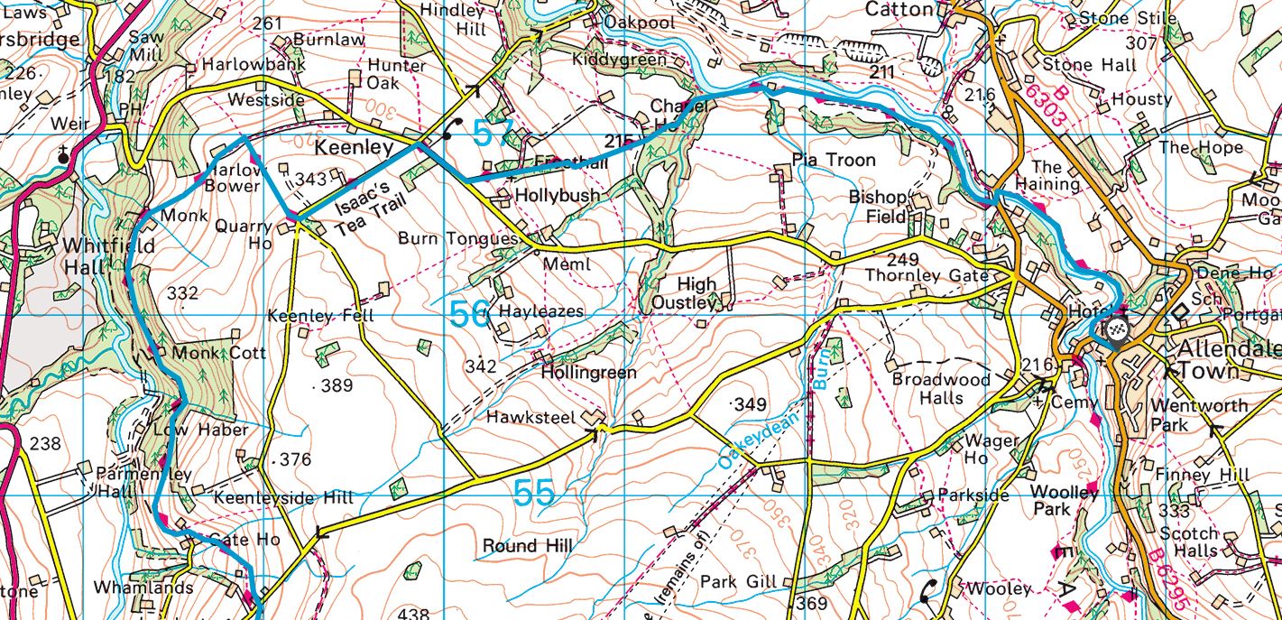
Allendale Town to (NY838558) to Keenley Green (NY792565) (6.3 km or 3.9 miles) – See map
Isaac’s Well is on the edge of the Market Place on the left as you enter Allendale Town from Hexham or Haydon Bridge. A few paces further along the road go right at the road signpost to Haltwistle 13, Whitfield 4, B6295. Follow as the road twists down the Peth to a fingerpost on the right, Allenmill Bridge ¾. Take this riverside path to Allenmill Bridge.
(Note that if you descend to the old Corn Mill Bridge you will have gone too far and will be headed out on the clockwise trail, not the anti-clockwise trail as per this route description)
Turn left over the Allenmill bridge and then right through a kissing gate at a fingerpost, Oakpool 2. Continue on footpath through Tommy Stout’s Wood noting the diversion up and out of the wood at the end. Initially on grassy path for 500 yards and then on vehicle track to the house of Bridge Eal. The waymarked right of way takes you partly through Bridge Eal’s garden. Then across field to step stile over wall and then across Maggie’s footbridge. Ascend from a marker post and sign up through the mixed woodland on at times faint path to go through a wicket gate. Continue on grassy footpath above Crockton Burn keeping right at footpath intersection to a stile into field.
When emerging into the field there is a choice of two footpaths. Isaac’s Tea Trail is the left one across the field to a stile next to a field gate. Across the vehicle track for Chapel House/Lowfrost Hall to a wicket gate next to a field gate, which you go through.
Across field to left hand side of a narrow copse. Continue to slightly ascend through field with copse on your right. A yellow post marker comes into view on top of fence in the corner of field, then over stile into a narrow copse. Through the copse to a wooden gate and ahead on the road. Unfasten iron gates if they are closed and Keenley Chapel is on your left. Continue ahead on road to junction with larger road, where you turn right and walk to the crossroads at Keenleywell House (old school with bell tower).
Turn left, signposted to Ninebanks on road for ½ mile to below Quarry House at Keenley Green.
Keenley Green (NY792565) to Leadgate Bank (NY789544) (4 km or 2.5 miles) – See Map
At Keenley Green there is a fingerpost on the right showing you the right way over a step stile then bear right off the track to the ladder stile over the wall next to the field gate . Continue through fields keeping the wall to the left and crossing ladder stiles until the well used farm track. Turn left along the farm track to Harlow Bower farm and go through gate with barn on left and farm on the right. Then descend down the next field, initially with a wall on your right, but then leaving the wall continue to a gate/stile combination gate in the corner of the field. Through the gate then descend next field using line of pylons as a guide to go through a wicket gate and then another field to reach the field gate to Monk Farm.
Cross the farmyard to a splendid double fingerpost ( Leadgate Bank, 1.5 miles, Harlow Bower ½ mile). Turn left in the direction of Leadgate Bank. Continue for a mile on the footpath through Monk Wood. Go through exit gate from Monk Wood. Enter field initially keeping wall to the left but then bearing half right after 100 yards on indistinct grassy path to marker post, turn left onto track. Follow track to go through gate onto road. Turn left at road and follow road as it ascends and bends right to a new field gate in front of Low House, which you go through. There are 2 footpaths to choose from here, either straight ahead or half right. You take the half right footpath keeping to the left of the wind turbine and then descend to field gate. Through the field gate and ascend diagonally across field towards property with large tree house. Through field gate or step stile. Onto and over ladder stile, across field to go through wicket gate, then below Newhouses, through further gate to the road at Leadgate Bank
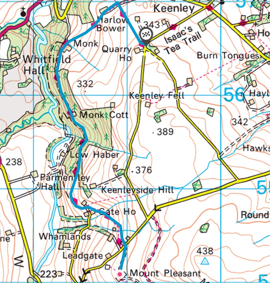
Leadgate Bank (NY789544) to St Marks Church, Ninebanks (NY783524) (3.3 km or 2 miles) – See map
Turn left on the road for 15 metres or so, then right onto farm track fingerposted to Mount Pleasant and Pasturehead. After 250 metres the track divides and you have a choice here.
(1) The actual Right of Way takes the right track. Pass between farm buildings and through a field gate. Cross field slightly left to go through large gap in wall. Walk through next field with wall and buildings to your left, over step stile into a garden, then immediately left through a wicket gate, then across access track to go over fence stile. Turn immediately right for 25 yards and then through wicket gate into a garden. Pass building on right. Currently the way involves ascending up the property drive (Spring House) for a short distance then a path appears on the right through a small area of trees to ascend to a farm track. At the farm track turn right and continue along the track to a marker post by the track.
(2) Alternatively, take the left track and continue on this track for 800 metres passing houses on your right to reach the same marker post by the track.
At the marker post leave the track to descend right on a grassy path to cross an open sided stone bridge. Head towards marker post then pass to the left of a solitary alder tree then over a further stile (although there is a huge hole in the stone wall next to the stile which is far more likely to be used).
Cross Dryburn Footbridge, then ascend steeply to reach a short, wet muddy section, then pass by the left side of Far Dryburn. Join farm track. After about ¼ mile along the track, leave the track on the left to a field gate. Pass through gate and then through a further two gates. Continue through a wet, tussocky field guided by two marker posts to reach a ladder stile. Over ladder stile, turn immediately right to a further ladder stile about 40 yards away. Over this ladder stile, to bear half left on grassy path past marker post to a further marker post where the path meets a farm track/road. A finger post directs left to Ninebanks Church and the Hearse House.
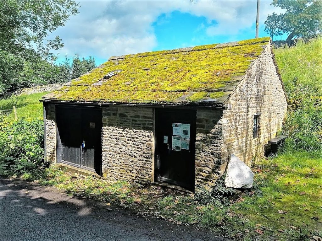
At this point there is a very worthwhile option to visit St Marks Church and the Hearse House. To do this follow the direction of the signpost through a wooden wicket gate into the graveyard of St Marks Church. Turn right and walk past the church and Community Hall and old school buildings on your left to emerge onto the Ninebanks-Carrshield road. Continue on the road for a short distance to reach the Hearse House on the left. The Hearse House is a welcome shelter for walkers and also a micro museum to the trail and the North Pennines.
To return to the trail you can either retrace your steps to the Hearse House signpost at the bend in the farm track or simply walk back down the Ninebanks-Carrshield road to meet a footpath descending to the left through a gap in the fence.