
Downloadable Route Summary & Instructions for Nenthead to Allendale Town
From Nenthead the trail ascends onto the moors to reach it’s highest point (585m) at the border of Westmorland and Northumberland. Then a descent into the hamlet of Coalcleugh which lies at the very head of the West Allen Valley. In the 1700s Coalcleugh was at the forefront of mining innovations and home to upwards of 200 miners and their families, with a public house, library, allotments, chapel and a rectory.
From Coalcleugh the trail steadily climbs back onto the moors by the Black Way. The mass of Killhope looms to the south, to your right as you start to ascend the Black Way. Apparent along the Black Way is the paraphernalia of grouse shooting with feeding stations and white plastic markers, complete with lines of stone and timber reinforced butts. Other than for spells when grouse shooting is underway from 12th August into the autumn, it’s mostly tranquil. People are few and far between with just the cries of lapwings, calls of curlews and tweets from golden plover on the tops for company around nesting times. Under the watchful eye of an occasional bird of prey such as the short-eared owl.
In the heyday of the lead mines this route was much travelled with heavily laden ponies making their way over the moors carrying lead ore to be smelted. Walking this open and weather-worn landscape, it is hard to imagine the great fortune carried away from below with no more than an indistinct track as a reminder.
The Black Way eventually returns us to the more pastoral scene of the East Allen Valley, “The Valley of the Shining Water” in Celtic. Past the Rowantree Stob Bastle (defensive farmstead) and onto Pry Hill.
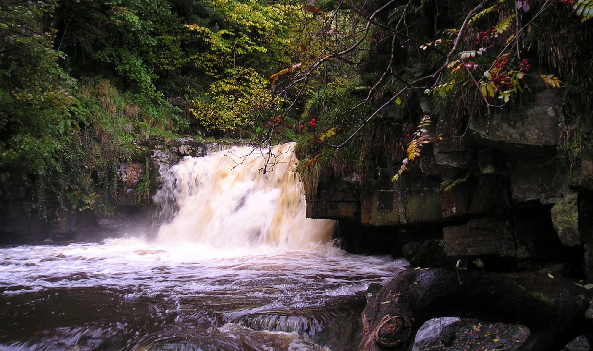
We now have the final four miles or so of the trail in the company of the East Allen River. The river is mostly out of view but the path never strays far from it, passing through wooded denes over tributary burns or across hay meadows or where sheep, cattle and horses graze. Behind such pastoral images is a fascinating industrial history when the valley led the world, albeit briefly, in mining technology.
By the mid 1800’s it was the Silicon Valley of its day with revolutionary hydraulic engines from W.G. Armstrong’s Elswick works in Newcastle installed in the shafts to drain Blackett Level mines. So named after the landowners, the Blackett Beaumonts, it was an ambitious engineering project for an underground channel up from Allendale to Allenheads. It was also intended to discover new mineral veins. In the long run, the costly scheme was not a success.
The impressive memorial to Isaac’s memory in St Cuthbert’s churchyard (behind the Allendale Co-op) can be admired before you return to Isaac’s Well. Allow time for a celebratory tea or the drink of your choice.
Accommodation and refreshments are available in Allendale.
Distance: 18 kms, 11.3 miles; Allow 6 hours
Difficulty: Medium
Max height: 585m; Min height: 211m; Total Climb: 359m
Maps: Nenthead to Allendale Town
Route Instructions
Nenthead NY 782437 (Bainbridge Memorial) – Coalcleugh GR NY 802452 – See Map
Distance 4.2 km or 2.6 miles
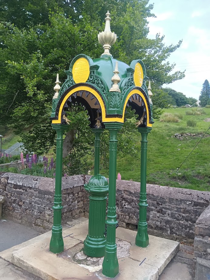
From the Bainbridge Memorial Water Pump, head NE up the minor road, with the stream coming down on your right and the community shop on your left. After 30 metres at a fingerpost bear left with the road ignoring the right turn along Granary Lane. The road becomes a lovely cobbled lane which ascends about 50 metres to the Old School Building. Continue on the road as it turns right and ascends.
After 200 metres the road bends left entering the area known as Whitehall. Continue and look for the ‘Old Peter’ clock face on a dwelling on the left on what is now Dykeheads Road. This was originally in Nenthead Market Place, the other 3 clock faces seen from every direction, have since been lost. Continue on the road until just after passing a house called Hazelcroft on the right to then turn right and ascend access track to agricultural buildings. After 150 metres on reaching the farm turn left on track; do not continue straight on into the farmyard areas of modern barns. Contour along this track, with hopefully fine views of the Nent Valley to your left. Continue straight on as the track becomes a footpath with old mine workings to your left. Pass through an old metal field gate. You are now on a rough path which turns left towards ‘Roughside’ a farm ruin. At the first building of Roughside, turn right to follow the grassy path to reach the fingerpost/wooden seat combination looking back on Roughside. At the fingerpost turn right (Coalcleugh 1 ¼ miles). Almost immediately pass through an opening in stone wall and go into open moorland. Follow the yellow topped wooden posts in an ESE direction to the county boundary (NY791452).
Go through the county boundary wicket gate and continue straight ahead. Being guided by yellow topped marker posts gradually descend on narrow path through moor grasses and heather. Views to the right of Killhope Law. As you approach Coalcleugh the path descends more steeply through old mine workings. At the meeting of larger track turn right along the track. Cross wooden footbridge across Alston Cleugh and then through a metal field gate. Pass the house, Sunniside, on the left with it’s large wind turbine. Continue to reach the road.
Coalcleugh GR NY 802452 to High Knock Shield GR NY 838500 – See Map
Distance 6.5 km or 4 miles
Total distance walked 11 km or 6.6 miles
Turn left onto the road for 30 metres to then turn right along another minor road signposted Allenheads 5 miles. Continue along road to pass Mutton Hall on the left, which is actually a barn not a hall. Descend to cross over road bridge. Ascend 30 metres to reach a fingerpost on the left (public bridleway, Black Way, East Allendale 5).
Leave the road on the left along the Black Way, which we will now be following for the next 4 miles or so. Initially the path can be indistinct, but gradually ascend keeping the wall to your left. Passing the remains of Rushymea part company with the wall as you continue to ascend up to Carrshield Moor using yellow topped marker posts to guide. At the crossroads of paths on Carrshield Moor, GR NY812465 continue ahead along the Black Way. The path is sometimes indistinct and boggy, but there are a series of yellow topped marker posts to follow (not to be confused by other posts for grouse beaters or grit feeder stations found near this bridleway).
Pass through Nan Davison’s Cleugh, then Phillipson’s sheepfold to your left. Superb views of the East Allen Valley open up. Weather permitting there are far reaching views north across Northumberland to the Cheviot Hills.
Descend to meet a large track near a three blade fingerpost. Turn left onto the track (East Allendale ¾ mile). Continue to descend on this track. Ignore large track off to the left at a culvert marked by huge white boulders. Continue descent to reach the large moor field gate.
High Knock Shield GR NY838500 to Pry Hill GR NY839518 – See map
Distance 2.2 km or 1.4 miles
Total distance walked 13.5 km or 8 miles
Through the Black Way field gate at NY838500. Continue on the Black Way (now a road) shortly passing the drive to High Knockshield farm on the left, for 500 metres to reach the road junction at NY840505. Turn left at the road junction and continue to pass the buildings of Knockshield on the left. Descend to cross the Knockshield Burn.
After ascending for 75 metres on the road look out for a footpath on the right – there is a fingerpost (Pry Hill ¾ mile), but it is cunningly hidden behind bushes. Take this footpath on the right, through a wooden field gate. Bear left keeping the field boundary which is initially a wall to your left and the drop to Knockshield Burn to your right. Continue as the field boundary changes from a wall to a fence. About 30 metres short of Knockburn Farm cross to other side of fence using stile. Pass the entrance to Knockburn farm to reach the field corner.
Over ladder stile then immediately right over another ladder stile. Then left over a step stile. Continue with fence on left with the ground sloping away to the right, through a wicket gate to then descend to a footbridge over Hole Sike.
Ascend to marker post. Continue on footpath for 200 metres through fields to arrive at Rowantree Stob Bastle. Passing the bastle on your left cross the footbridge over the Knockshield Burn. Turn left and follow the meander of the burn to reach the footbridges where Knockshield Burn meets the East Allen River.
Cross the wooden bridge across the Knockshield Burn ignoring the larger bridge across the East Allen itself. Using the obvious marker posts for guidance zig-zag up the rough hillside to eventually reach and go up some steep wooden steps.
Through a metal wicket gate into field. After 30 metres through another metal wicket gate. Keep to the right of the farm buildings and when past the buildings look left for another metal wicket gate. Through this gate then straight away over a large stone step stile into field. Turn right and keeping farm buildings to your right continue through rough field to eventually go over stile to minor road at Pry Hill.
Pry Hill, East Allen (NY839518) to Allendale (Isaac’s Well) NY838558 – See Map
Distance 5.6 km or 3.5 miles
Total distance walked 19 km or 12 miles
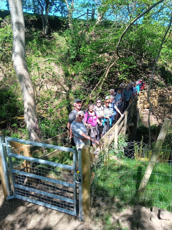
Turn right onto the minor road past the entrance to Pry Hill Farm and after a short distance turn left off the road at the fingerpost (Peckriding 2 miles). On footpath across field, keeping the fence to your right for 150 metres, then over a stile. Descend for 200 metres, initially on grass then steps then boardwalk to cross the footbridge over the Acton Burn.
Ascend the hillside straight up in a northerly direction eventually bearing right to reach and go through a wicket gate (Virginia Ursula Nelson gate). North for a further 100 metres across field to go through another wicket gate. Then a further northerly 100 metres across another field to go through a further wicket gate.
In 100 metres reach the four way fingerpost in it’s own enclosure. Continue straight on in the fingerpost direction of Park. Descend to cross a burn using a wooden single railed footbridge. Continue on obvious path to cross another burn on another single railed footbridge. Continue through a wicket gate to then cross the Newshield Burn with a two railed wooden footbridge. Ascend up to a kissing gate and cross fields to reach Park Farm.
At Park Farm keep the farm buildings to your left and continue to then cross the Park Burn if necessary using the double railed wooden footbridge. Continue on waymarked footpath through fields and over a ladder stile, or the field gate if open, to continue on by the riverside to go through a green metal wicket gate (Mavis’s Gate). Do not cross the large iron lattice work Studdon Bridge to your right but continue straight on with the East Allen river to your right. In a short distance go through a large metal field gate. Cross over the Hagg Burn then take the public footpath to your right not the byway to the left. The river East Allen is now still on your right as you proceed along what can at times be a muddy footpath, past a ruin on your right.
At the horse paddocks initially keep the wall to your left but then go through a hole in the wall to bring you to Peckriding Bridge and the towering cliffs opposite. Continue on past, not crossing this bridge.
Cross the Steel Burn wooden footbridge and ascend steps to pass the off-grid house, Steelwood Villa on your right.
Go through metal wicket gate next to field gate into field. Follow directional markers diagonally up this field to a marker post. Follow directional markers keeping the fence to your left, ignoring a ladder stile to your left along the way. Reach and go through a metal wicket gate next to a metal field gate. Then half right across rush filled rough field at Black Cleugh. Through a broken wall and then over a stile. Half right across the next field to then go over ladder stile with planks over a ditch.
Half right across field above Wooley Scar to reach stile next to metal field gate between Sycamore trees. Continue with wire and post fence to your left and ground dropping away to your right. Over step stile. Then over ladder stile into field corner.
Through fields with the fence to your right to eventually reach a white wicket gate. Through this gate and continue along tarmac lane with river to your right. Turn right at the road across the Old Corn Mill Bridge. After the Old Corn Mill Bridge ignore the fingerpost and markers (Allenmill ¾) or you will be starting another 37 mile loop. Continue using the roadside footway to ascend and bear right steeply up the Peth to reach Allendale Town Market Square. Retrace your steps to finish the trail at Isaac’s Well.